
A History of Stoke Gifford by Mike Hill
Biographical note.
Mike Hill was born in June 1930 in a hamlet in Northamptonshire. His father was
kennel huntsman to the local foot beagles. Mike rebelled against living in the
most land-locked English county and joined the Navy in 1945. He signed on as
Naval apprentice and just missed the war and served in Suez and Korea during his
15 years. It was whilst based at Chatham Dockyard in 1952 that he met his wife
to be Gladys (later known as Lynne) at a firework display. They married in 1953
and had two daughters. They lived in Chatham until Mike left the Navy in 1960.
The family moved to Little Stoke when Mike took a job as a project engineer at
Bristol Aircraft Company (later British Aerospace). He later joined a technical
publications company based in Bath and retired to their house in Gadshill Drive.
[Editor’s note: Not all of the notes below have been located, where material
listed below duplicates that already in other histories it has not been included
.]
HISTORY OF STOKE GIFFORD
INTRODUCTION
Extent of research
Principal roads, farms, houses and fields
Source of information
ORIGIN OF PLACE NAME
Stoke Gifford
Watch Elm
Excavations At Baileys Court
Osbourn Gifford's Dispute
Excavations at Parsonage Field
Historical Monuments In The Church
Extract From "Stoke Gifford Village History"
Stoke Gifford from Doomsday Book:
Roman Coins
Other Roman Remains
Saxon Way
Manor House
Stoke Gifford Riots
Sale of Estate
Ghosts
The Church
Misc. Notes
Observations From Ordinance Survey Map 1903
Extract From Tithes Map Of 1846
Extract From Somerset Wills
Extracts From Headstones In Churchyard
Lords Of The Manor
Extract Applicable To Stoke Gifford From Patchway Roundabout
Extracts From Local History Of Winterbourne. Frampton Cotterell & S.G.
Scandal In Gloucestershire In 15thc
Sale Of Stoke Gifford Estate In 1915
Statistics From Stoke Gifford Census
Nipress Family
DENT FAMILY
WIGMORE FAMILY
EXTRACT FROM FILTON HISTORY APPLICABLE TO STOKE GIFFORD
NOTES OF CONVERSATION WITH MRS PETRIE
KELLY’S 7 WRIGHTS DIRECTORIES FOR S.G
1875
1897
1906
1923
1931
1939
RESIDENTS NORTH END OF S.G.
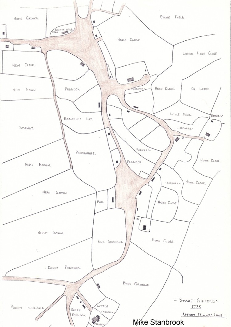
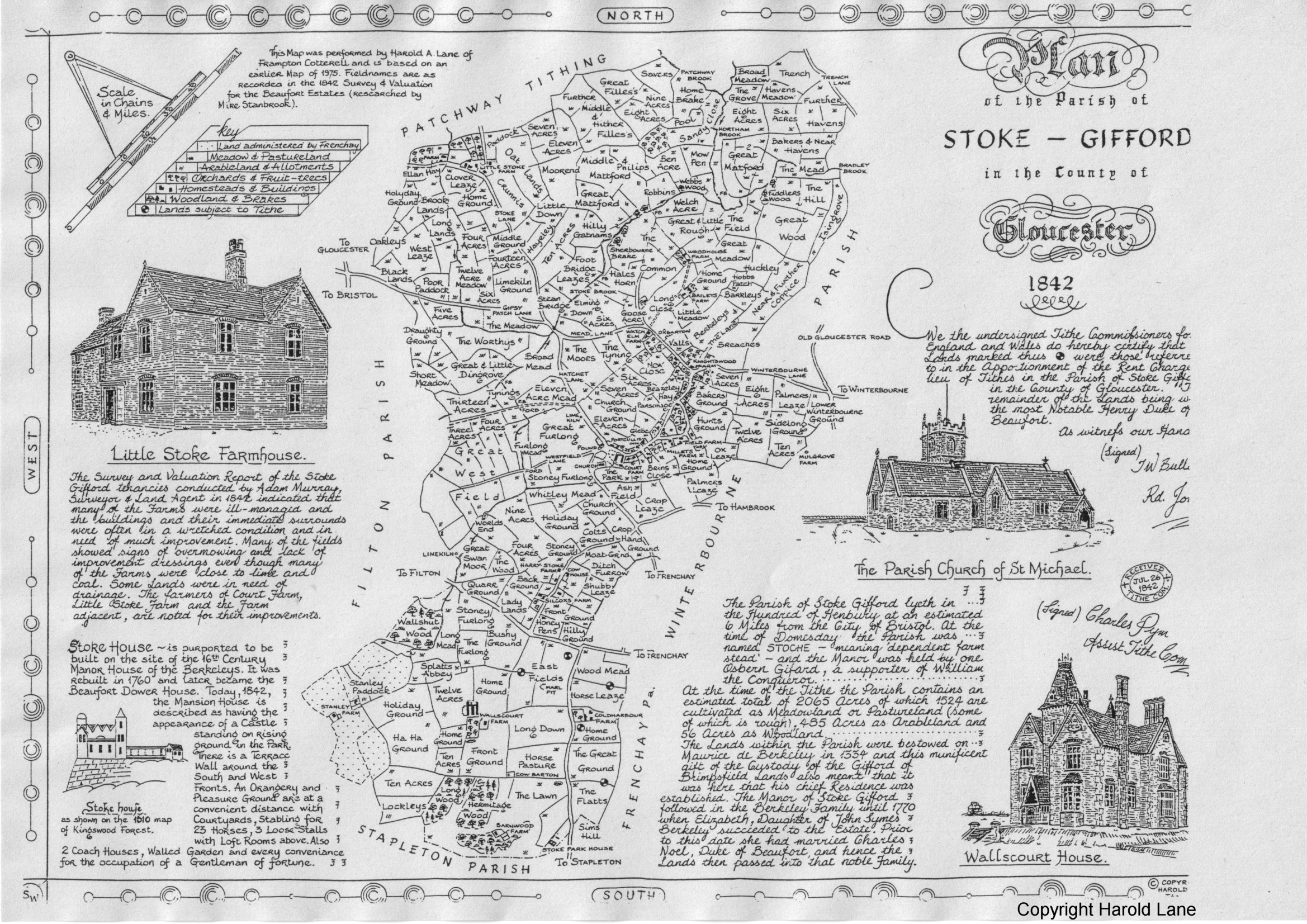
MAP OF 1842
1382
1830
1830 (Part)
1935
1960
C1900
C1988
Sketch Walls Court Farm
Photos
Stokes Standard Extra Photos
History And Guide To Parish Church Of St. Michael’s
The Archaeology Of Stoke Park
Sketch Of The Watch Elm
Working Roughs Of 1841 To 1891 Censuses
TIMES AROUND THE WATCH ELM
(A Digest of local history)
27th January, 1995
This shortened version of the history of STOKE
GIFFORD is written for the amusement of the author, it is not intended for
publication or to replace any other document that is available in our libraries.
The area of this study was to have concentrated around the bottom of Mead Road
where the Watch Elm Farm was located. Later this farm was known as Mead Barn
Farm and was an uninhabited collection of barns, sheds and out buildings within
the farmyard enclosure. On starting the research it was soon evident that it was
unwise, if not impossible, not to include the rest of the village which lies to
the north of the existing main railway line.
It is however intended to concentrate my research to the area stated below
West : Hatchet Lane & Stoke Brook:
No r t h: Sherbourne Brake, Woodhouse or Webbs Farm
East: The Lane from Knightwood Farm to Barkley
South: Junction of North Road with Winterbourne Road through to the centre of
Hatchet Road.
PRINCIPAL ROADS IN AREA
Mead Rd., Mead Lane, Winterbourne Rd., Hatchet Road. North Road, Bailey's Court
Road.
PRINCIPAL FARMS IN AREA
Bailey's Court Farm, Webbs Farm or Woodhouse farm), Knightwood Farm, Watch Elm
Farm or Mead Barn Farm).
PRINCIPAL COTTAGES IN AREA
Little Lease Cottage, houses in Mead Road, Knightwood Road, North Road and
Winterbourne Road.
PRINCIPAL FIELD NAMES IN AREA
From 1842 Map of the area the field names are as follows :-
The Common, Hales Horn, Home Ground, Hobbs Patch, Barkleys, Berkeleys, The Lane,
Long Close, Little Meadow, Elming Down, Six Acres, Goose Acre, Oxbarton, Valls,
Breaches, The Moors, The Tyning, New Close,
PRINCIPAL SOURCES OF INFORMATION,
A Village History. Stoke Gifford, by Ros Broomhead
The Stokes Standard, by Sharon Ubank.
A Short History Of Stoke Gifford, by Rev. D. R. Evans (1955-1972)
History of Filton by W. L. Harris. ISDN 0 950738700 BK386
Stoke Gifford Tythes. Info. supplied Jan 1983 Info Box
Stoke Gifford Estate Sale 1915 9492(603
Stoke Gifford Estate 1915 35810/WWP/F/385S CC Deposit
TC1s Departmental Documents Deposited 49840-3)
Stoke Gifford Manor, CC deposit 21782 (not available to the public)
Stoke Gifford Parish Council Deposits 352320-76)
Parish Records for Stoke Gifford :-
P/SG/R Registers P/SG/1 incubants
P/S6/ChW Churchwardens P/SG/X Misc.
P/SG/SD Statuary Deposits 35232 (1-76 )
Bristol City Library, Census,
Films for Stoke Gifford :- 1841 ROLL 4; 1851 ROLL 24; 1861 ROLL 16; 1871 ROLL
24; 1881 ROLL 20; 1891 N.K.
MAP OF 1846
(See Also O. S. Maps 279 (a)1915; 2400)1903; 2420)1903; 2420)1915; 242(01935;
242(d)1948.)
This indicates Watch Elm Farm to be opposite to a lane running from Mead Road,
past Baileys Farm and Woodhouse Farm, terminating at Fiddlers Wood and Hen Roost
Farm. This is now roughly the line of Pursey Drive and Webbs Wood Road. On a
later map the Watch Elm Farm is named as Mead Barn Farm. The Watch Elm tree would
appear to be located in the fields adjacent to Baileys Farm.
Stoke Gifford appears as Stoche Estoch (10S6 Doomsday Book)
Stokes Helie (1187)
Stok(e) (1221-1287)
Elye Giffordi (1221)
Giffardi (1255)
Syffard (1268)
Stoe C this refers to an Independent farmstead)
The Manor was held by Osborne Gifford in 1086, (Doomsday Book) and by Helyas
Gifford in 1169. It continued in the possession of the Giffard family until at
least the 14th century.
Other variations of spelling included the WATCH ELM (1830) meaning "look--out
elm) from the old English Waeccelm
The Gentleman’s magazine of 1766 (see etching by John Player, taken in the
summer of 1765).
This famous elm must have stood near Baileys Court Farm. it was described as
being one of the largest trees in the country and so very ancient that no one
could remember it being in a sound state.
In earlier times it was where those met who were appointed to do watch and ward,
and it being the standard whence they went to make there respective rounds. In
other words the meeting point for the local neighbourhood watch.
A writer in the 17th century stated it was over 90 years old and was known as
the Hollow tree that provided shelter for hogs, sheep and the like. Most of it
was dead with one small portion of it flourishing. It was reported to be 41 feet
in circumference, at the height of 2 feet above the ground. It's height at the
lowest part where it was broken down was 8 feet.
It was blown down in a storm in 1760 and disappeared altogether in about 1860.
EXCAVATIONS AT BAILEYS COURT FARM by J.Russel.1989, Bristol and Avon
Archaeological Society,
Bristol & Gloucester Archaeological Society 1988 Vol 106
DISPUTE. Regarding Osbourne Giffard's 5 hides held throughout the 12th and 13th
centuries are related to a controversy regarding the overlordship of Stoke
Gifford Manor.
Throughout the 12th and 13th centuries the Bishop of Worcester maintained that
the 5 hides of Stoke Gifford formed a knights fee held by the Giffards for the
Bishops. it was not until 1280 did the Crown and the Giffards acknowledge the
overlordships of the bishops, as a result Stoke Gifford came under the
jurisdiction of Henbury Hundred, (the successor to Brentry Hundred) down to the
19th century.
PARSONAGE FIELD. There are two main areas of medieval occupation, large
quantities of 12th-14th pottery have been found and evidence of a timber
structure. From mid 14th century there were stone buildings including a large
farm house and probably the parsonage which may have disappeared by the mid 18th
century.
HISTORICAL MONUMENTS IN STOKE GIFFORD. Gloucester Record Series Vol.15, Original
papers by Ralph Bigland. Part 3 edited by Brian Frith. Ref. CCLW or 256
(PAGE1170)
States church is small, comprises chancel, nave and north aisle separated from
nave by two fluted pillars. It was thoroughly repaired by Lord Botetourt about
30 years ago. Its neat and well pewed. Present Lord of the Manor is His Grace
the Duke of Beaufort. J. Foxeroft, Vicar.
Benefaction Table.
John Silcocks, yeoman, left by will interest of £200 to be given annually in
bread to 12 poor people not receiving alms and the interest of £100 in a
reversion to be applied to the same. He also gave the interest of £50 for
teaching poor children to read and the interest of £50 for preaching 4 sermons
yearly on the first Sunday after quarter day for seven years.
John Silcocks was a farmer of Stoke Gifford who also rented fields in the
parishes of Filton Winterbourne and Almondsbury. In his will dated 22nd July
1741 he bequeathed to the Rector of Filton the sum of £50 to the Churchwardens
and Overseers of the Poor, the interest of which was to be paid to the Minister
to preach four sermons annually. Silcocks died on 14th November 1741 and is
buried in Stoke Gifford churchyard. It seems he paid for sermons in both
parishes.
(a) Richard Berkeley and Family (about 1661)
(b) Elizabeth Dorothy Cavendish, aged 13 weeks, dated 17/9/1786
(c) Norborne Berkeley (Baron de Botetourt and family, about 1760)
(d) John Symes Berkeley (Second son of Richard Berkeley) and family
Grave Stones (several illegible in 1875
Richard Stevens
Anne Knapp
Elizabeth Parker
Arthur Silcocks
John Silcocks
Richard Lawford
Rebecca Lawford
Thomas Lawford
Robert Lawford
Christian Lawford 3 May 1681 aged 61
24 Sept.1685 aged 29
19 March 1689 aged 24
9 April 1743 aged 70
14 Nov 1741 aged 58
27 April 1710 aged 89
29 April 1680?
15 July 1707 aged 19
20th Feb 1711 aged 27
11 June 1720 aged 60
Church Yard on Tombs
Alice Millet
Jacob Millet
Elizabeth Millet
Daniel Millet 6th July 1747 aged 7
25 March 1753 aged 57
6 July 1760 aged 58
29 Nov 1759 aged 22
(see other supplementary information compiled about 1875)
In 1765 Heads of Family was 111
Children
86
Servants
53
Population in 1811 - 315
1831 - 441
1871 - 490
STOKE GIFFORD From The Doomsday Book 1084-1086
The parish of Stoke Gifford lies in the Hundred of Henbury, 4 miles distant
north of Bristol, G miles south west from Sodbury and 32 miles south west of
Gloucester. it has the additional name of Giffard from its belonging to the
family of Giffard of Brimsfield. Duns a Thane, held Stoke in the Ledbury Hundred
in the reign of Edward The Confessor. Osbern Giffard held it in the reign of
King William The Conqueror.
ROMAN COINS
A horde of Roman coins were found by a young artisan from Bristol on Sunday
4th April 1880 when gathering primroses on the bank of Stoke Brook. He
apparently threw stones at some pottery he saw laying in the bank of the stream.
The pot was broken and out poured an avalanche of coins. He was observed by two
men, James Tily and Harry King, who stated that the position of the discovery
was much closer to the Filton/Patchway road (A38) than is shown on the Ordinance
Survey map. One of the two men is reported to have picked up 17 coins and
retained them without making a declaration. Another report states that there
were two local youths throwing stones at the pot of coins.
The majority of the coins were of low value, mostly mites and farthings with a
few to the value of eight mites. There is some conflict as to the date of the
coins, one report states they were of the reign of Constantine The Great, with
some of the reign of Emperor Domition. Another report states they were of the
period between Licinus and Constans, probably AD270-AD350. Altogether there were
over 3000 coins weighing over 1 cwt.
OTHER ROMAN REMAINS
A Mr Nichols in 1880 reports that the spot where the Roman coins were found is
close to an old road, now a deep lane (Hatchet Lane) which joined the Ridgeway
to the Iter of Antonius (Caerwent to Bath) road. The two roads would intersect
at nearly a right angle. This curved byroad connected with the above main road
without entering Bristol. It leaves the Ridgeway close to Pen Park, an old Roman
lead mine which is named the place of diggings in a deed witnessed by Alfred the
Great. It passes to a Cold Harbour near to Netherways, a Roman sanatorium with
three flat terraces overlooking a well. This spot bears the marks of an
enclosure by a ditch and vallum. The old road above joined the road to Bath at
Easton. (Further research into the above is required.) A pavement of Roman
origin was found in the Mead Rd. area. (This also warrants further
investigation) The population both rural and military was quite extensive in
this area during the Roman occupation. It has been stated that at one time the
population of the area excluding the large towns, was greater in the Roman era
than it is today.
A Miss Blanford, historian and one time Filton librarian, described an ancient
trackway known as The Patchway running across Smithy's Field, probably coming to
Gypsy Patch Lane following the brook, crossing where the railway line is now, to
the church and across the public footpath to Coldharbour Lane. This track
branched from the Gloucester (Glevium) Road to Sea Mills. J am not to sure where
Smithy’s Field is located.)
The Romans moved out of the area about 350AD.
A double hedged pathway within the town of Bradley Stoke near Webbs Wood and
running from the Patchway direction to Gypsy Patch Lane is acknowledged to be a
Saxon track. This lane joins Baileys Court Road with Winterbourne Road. in
medieval times the main grazing common for the parishioners of Stoke Gifford was
in the Mead Road area.
The Manor House for the village was located Parsonage Field in what is now known
as North Road. Excavations by James Russell in 1937 indicates that the Parsonage
Field site was in almost continuous occupation between the 12th and 18th
centuries. The same would apply to the Mead Road area.
The Giffords lost the estate in 1323. Records indicate that the manor house
thrived during the 16th century but was pulled down about the year 1600. The
associated farm was reconstructed and developed well into the late 17th century.
By the mid 18th century it had again declined and was in disrepair by 1735. In
1766 it did not exist.
Stoke Gifford Riots ?
In King Richards II reign there appears to have been a dispute regarding the use
of common land within this area. An investigation was called " to enquire of the
parcel of land which Maurice Berkeley had enclosed at Stoke and thereby made a
park without the Kings licence, wherein many of the Kings leige people claimed
common. The above (Maurice Berkeley ?) to arrest divers rebellious persons in
Stoke, Winterbourne and Frampton Cottrel who 'war likely' arrayed and made some
attempts there upon".
Stoke Gifford Estate was sold by the Duke of Beaufort at public auction on
November 4th 1915. The sale comprised 2300 acres "lock, stock and barrel"
including 8 dairy farms and several small holdings. The farms included Baileys
Court, Knightwood and Little Stoke which was the largest. There were 70 lots in
total, most were sold to the existing tenants. (See report of sale on following
pages)
Ghosts
There seemed to have been several sightings of animals such as goats, mules and
dogs on the common land at the end of Mead Road. The location of this common
land is uncertain, it was probably where Oxbarton is now.
The Church
Cromwell’s men attacked the church during the Civil War, the 13th century
stained glass window remains unscathed as the only piece of the original stained
glass. There was a church 'Skole’ in the village in Charles I time with Robert
Lawford, of a farming family, as the headmaster.
David Railton Jones, vicar of St. Michael’s, lodged with Mr and Mrs Powell at
Jasmine Cottage, Mead Road, before moving to the vicarage in 1917.
Dan Smith of Court Farm kept Gloucester Old Spot pigs as well as a dairy herd
and sold land for the first new houses. (When?)
Buses ran 7 days a week in the 1920s and 1930s from Fishponds - wonder where the
bus stop was located?
At one time "Silverdale" in North Road had been a Dukes hunting lodge, the
living quarters being the main part and the stables located at the side. Grooms
slept over the stables. There was a smithy next door.
A Neville Scott, related to the explorer, had polo ponies stabled at Harry Stoke
Farm, renamed the paddocks. Mr Scott lived at "The Cottage" next to Baileys
Court Farm (Early 1900s). This cottage was later occupied by Mr Bill Woodward
and demolished in 1992. Peter Scott was a friend of Mr Davies of little Stoke
Farm. (see later).
The Pursey family lived at Baileys Court Farm and were often hosts to the
Berkeley Hunt. They also had the local pack of beagles meet at the farm. Edmund Pursey who moved to Bailey's Court Farm from Filton had a younger brother, Joe,
who was a keen sportsman. He played cricket followed the Beagles and took part
in games of polo with officers from Horfield Barracks. Edmund Pursey was a keen
clay pigeon shot and shot for the England team. The well known doctor and
Cricketer, W. G. Grace was said to be a friend of the Pursey family. Would he
have approved of the modern cricket pitch and pavilion just outside Mr Pursey's
front door?
In 1930, the Duke and Duchess of York, later to become King George VI and Queen,
Elizabeth, passed through the village on their way to Badminton House. it is
reported that as they passed over the Stoke Brook at the end of Gypsy Patch Lane
their large car was brought to a stop by a small dog named Sandy. I wonder if
the Queen Mum remembers Sandy of Little Stoke?
A ducking pond was located was located on the Green opposite the Beaufort inn.
To the right of Knightwood Road towards Winterbourne is land whose boundary was
in dispute with the parishioners of Winterbourne. The farmers agreed that the
women of one of the parishes should have the gleaning rights and those rights
had to be settled by a contest. One woman was chosen from each parish and
following cries from the Stoke Gifford supporters to 'butt her, the Stoke
Gifford woman won. Quite a worthwhile punch-up as it was an important issue, the
corn gleaned provided the bread for the majority of the villagers for the whole
year.
At one time Stoke Brook ran across Gypsy Patch Lane as a ford. The Stoke Bridge
was rebuilt in 1326 for £40 and replaced by a modern bridge in late 1900.
Gypsy Patch Lane was a favourite spot for gypsies for very many years. It was at
one time known as Thoroughfare Lane and crossed the main Gloucester Road (A38)
into Hayes Lane, now a part of the Rolls Royce works. On the North side of Gypsy
Patch near the Rolls Royce offices was an area known as Hangman’s Paddock and
nearby a field called Blacklands. Appropriate for Rolls Royce offices?
A walled enclosure for the retention a straying animals was located in the
village quite close to what is now the Beaufort inn. A William Gayner, of Filton
is recorded having to pay a fine for the return of his animals.
Observations from the Ordinance Survey Map of 1903
The railway line running through Stoke Gifford is shown to be under construction
up to the junction with the Bristol to South Wales line. The embankments and
bridges appear to be completed but without the rails.
Where Pearce’s offices and yard are now located there is a substantial
brickworks with an internal railway system linking up to what will be the main
line. The brickyard was built to provide for the construction of the many
bridges and other railway building in the area.
There is a police station at the top end of Rock Lane just by a lane leading
into the brickworks.
A smithy stands at the north side of the triangle formed by North Road and Rock
Lane.
The old Portcullis inn stands in North Road about 100 yards up from the Post
Office. The 'new' Portcullis is where the Beaufort now stands.
A limekiln is located in Hatchet Lane roughly where the roundabout is now.
Extract from the Tithe Map EP/A/32/36 of Stoke Gifford for 1846
This apparently refers to the 114 acres of land which surrounds Coldharbour Farm
at the South end of Stoke Gifford. It appears that the majority of the land at
that time was owned by the Duke of Beaufort and amounted to 1949 acres for which
he received a rent of £390.5s.Od per annum. The 114 acres, 3 roods and perches
subject to a tythe net charge of £23.6s.Bd per annum was payable to the vicar.
The vicars glebe land of 3 roods was exempt from tithes.
Extracts from Somerset Wills - Brown Vol XI 1890
Proved May 22nd 1655
Sir Maurice Berkeley of Stoke Gifford. Will dated Nov.28 1653.
Lady Rowe, late wife of my uncle Sir Thomas Rowe, decd. My youngest son, George
Berkeley, my daughter Francis, my father Richard Berkeley.
Will administered by his son Richard Berkeley.
Proved May 7th 1685
George Berkeley of Stake Gifford. Will dated 1684.
To my brother John Symes Berkeley the Manor of Stoke Gifford, then to Brother
Richard, then kinsman Richard younger of Rendcombe, then Uncle George Berkeley.
My wife Jane B(erkeley) money owing to me from my grandmother Ann Symes (and) my
grandfather Harry Symes Esquire. My sisters Mary, Elizabeth, Ann and Penelope.
My father-in-law Maurice, Lord Viscount Fitzharding and Uncle Edward Birre.
Extract
PURSEY.
Edmund Thomas, husband of Francis Augusta Pursey of BAILEY'S COURT
FARM. Died 2/6/1922 aged 55.
Also Francis Augusta. Died 19/9/1955 aged 84
NIPRESS
Jane, Died 6/1/1950 aged 98
CLOSE.
Fanny Pauline, died 5/3/1903, wife of Admiral Francis Arden Close, Hon.
Commander Bristol R. N. Volunteers. High Sheriff of Bristol 1902. Admiral Close
died 25/8/1918. He moved to Stoke Park as a tenant of the Duke of Beaufort on
his retirement and after living for a time at Thornbury Castle. He involved
himself in parish affairs and was in dispute with Vicar Tibbits regarding
repairs to the church in 1894. The Duke of Beaufort supported the vicar and
Admiral Close had to resign his position on the council. (see Stoke Gifford
History page 11).
MERRICK.
Annie Delphine. Died 18/10/1933 aged 58
Alfred James. Died 3/10/1958 aged 99
PIERCE
Emily Jane. Died 5/10/33 aged 67
Frederick. Died 22/2/1952
Frederick Charles. Died 21/6/1961
PIERCE
Lucy Ann. Born 4/12/1878; Died 4/5/1961 aged 79
TIBBITS
Alice Julia. Born 4/12/1933; Died 21/9/1912 aged 79 Wife of Newman Tibbits the
Vicar of Stoke Gifford. Note: in the 1891 census Newman Tibbits was listed as a
bachelor aged 37 living with his older brother and two servants. Newman Tibbits
was born in 1854 and came from a village near Market Harborough in
Leicestershire. His wife would have been 21 years his senior.
DUNS Saxon Thane (Thegn or noble landowner) also held Brimsfield, Rockington and
Oldbury.
OSBERN GIFFARD Norman Count, given manors by William The Conqueror for services
at the time of the conquest. He came from Longueville la Gifarde near Scie.
HELIAS GIFFORD And others, some named John. Their lands were seized by King John
after the Barons revolt and the Magna Carta in 1215 but restored by King Henry
III in 1217. One Helias defied the Abbot of Gloucester by hanging his own men in
1221. Johann Gyffard le Rych fought the sheriff of Gloucester at Ruedgely in
1264.
SIR JOHN GIFFORD Joined rebellion against King Edward II and captured the city
of Gloucester by hiding in a bale of wool. He later raided the royal baggage
train. King Edward replied by destroying his castle at Gloucester and he was
hung, drawn and quartered at Gloucester. There was a monument to his memory in
Stoke Gifford church but it no longer there.
HUGH DISPENSER Was given the manor by King Edward U, no doubt following the
demise of Sir John Giffard.
SIR JOHN MALTRAVERS Was given the manor following the murder of Edward at
Berkely Castle in 1327. Sir John Maltravers was the Kings' jailer. The Earl of
Berkely was away from England at the time and was not held responsible for the
murder and was able to retain the castle.
MAURICE DE BERKELY held the manor from 1337.
SIR WILLIAM BERKELY Knighted by King Richard III in the 15th century. He fled
abroad after the Battle of Bosworth.
JASPER DUKE OF BEDFORD He held the estates after they were seized by King Henry
V111,
SIR WILLIAM BERKELY Received the estates back from Henry VIII.
JOHN BERKELY Son of the above William
RICHARD BERKELY
Lieutenant of The Tower Of London, he built the manor house at Stoke Park. He
survived the reigns of Henry III, Edward VII, Queen Elizabeth I and James I.
Quite an achievement.
SIR MAURICE BERKELY. Sat as member of Parliament during the reign of King James
I He was very POPULAR and provided the first records of the estates.
NORBORN Berkeley or LORD BOTEOURT Restored the manor at Stoke Park which made him
bankrupt. The Lordship of the manor then passed to his sister.
ELIZABETH THE DUCHESS OF BEAUFORT She gave the name to the Duchess's Pond and
other features about the Dower House.
10TH DUKE OF BEAUFORT He was responsible for the sale of the estates in 1915 to
meet death duties. He was also a host to Queen Mary during
The GIFFARDS held the manor for 200 years, the BERKELEYS held it for 400 years
and the BEAUFORTS held it for 145 years. The Giffards and Berkeleys held Stoke
and Walls. Harry Stoke was separate. It was held by Aldred, tenant of King
Harold in Saxon times, Theobold in Norman times and the Blount and de Filton
families in medieval times. The Berkeleys bought Harry Stoke Manor in the 16th
century.
EXTRACTS APPLICABLE TO STOKE GIFFORD FROM
PATCHWAY ROUNDABOUT
John Darren Agate 1979
The area was the territory of the Hwiccas but inhabited by the Dobuni and
several other tribes. An early decisive battle was supposed to have been fought
near here in 577AD and, incorrectly, stated that the last battle on English soil
was fought here in 1470.
Report in the Patchway Gazette of 577AD states:
Saxon Victory splits British Lands in two Dyrham Gloucestershire 577 AD
The Britons of Wales have been cut off from those of Devon and Cornwall by a
Saxon victory at Dyrham. Three British kings, Conmail, Condidan and Farinmail,
died in the battle against Saxon forces under Ceawlin and Cuthwine. The West
Saxons, especially those of the upper Thames valley under Ceawlin, have beef]
winning land from the Britons in recent years, and this victory puts the Romano
British cities of Bath, Gloucester and Cirencester in their hands. it opens up
much of the Cotswolds to German colonisation and drives a wedge between British
held lands.
A later edition of the Patchway Gazette dated March 20th 1470 reports the
following,
Viscount Is Stabbed In “Private” Battle . Avon 20th March 1470
Two private armies joined battle today at the village of Nibley Green. Victory
was secured by William Berkely over his arch rival, Thomas, Viscount Lisle. The
fighting began after the 19-year-old Lisle challenged Berkely to either single
combat or a pitched battle to resolve a legal row between them. A mob of small
boys climbed into the trees to watch the two armies clash. Berkely had recruited
miners and foresters led by "Black Will", an expert bow man. One of his arrows
felled Lisle, who was then swiftly knifed to death.
Little Stoke Farm at the junction of what is now Little Stoke Lane and Clay Lane
was the original hamlet of Little Stoke and was associated with a small cluster
of cottages. The stream near here was dammed for dipping sheep prior to the mid
summer shearing.
Little Stoke Farm was the property of the Duke of Beaufort and the last tenant
farmer was Mr Howard Davies, a local naturalist who was often visited by Peter
Scott. A bird sanctuary on The Isle of White is named after Mr Davies. The area
between Stoke Lane and Brookfield Road was a camp for the navies who dug the
railway cutting to the Seven Tunnel.
EXTRACTS FROM THE LOCAL HISTORY OF WINTERBOURNE FRAMPTON Cotterell AND STOKE
GIFFORD.
John Moore BA FRHist.
Stoke Gifford and Winterbourne churches have same dedication, although
Winterbourne was originally dedicated to St. Mary. They were probably combined
sometime before the conquest. A mysterious manor of Brokenborough seems to have
been in this area. It was originally a part of Winterbourne. Several records
from 1320 show that Stoke Gifford is also called Winterbourne Gifford. Evidence
is that Stoke Gifford and Brokenborough were all a part of the parish of
Winterbourne. About the year 1400 Stoke Gifford is said to be in the Lordship of
Frampton and Winterbourne. This is significant as it suggest that all three
parishes were combined although at no time between 1066? and 1802 were
Winterbourne and Frampton owned by the same person and neither owned by the
lords of Stoke Gifford. The combined parishes must have been sometime before
1066 and relate to the Anglo-Saxon 'parochial or mother parish".
In Roman times it appears from the field names on tithe maps that the
Brokenborough -Patchway section was a Roman estate. On the Weston/ Hempton/
Patchway boundary there was a Roman estate which was recognised by the Saxons
when they arrived.
Roman remains were found during an extension to the Cattybrook brickworks. Roman
remains were also found in Stoke Gifford at a villa and settlement to which a
coin-horde found in 1080 also relates.
The recorded population in the 12th century is as follows:
Bitton 160 Frampton Cotterell 105
Wapley and Codrington 80 Stoke Gifford 60
Winterbourne 120 Hambrook 10
Sturden 5.
Stoke Gifford was owned by the Giffards from the Conquest until 1321. The
population of all three parishes at this time was probably no more than 300 in
1086 (Doomsday).
The parish records for Frampton and Winterbourne disappear at about this time
and except for the manor of Sturden, start again in the middle of the 16th
century. At this time, in 1540, ex chantery lands passed to OEH and are well
documented in the Bristol Records Office.
Up to the early 1790s the principle occupation was agriculture for the whole
area, i.e., Winterbourne and the surrounding parishes. They enjoyed a reasonable
standard of living as Bristol and Bath ware expanding and required local
produce. Stoke Gifford probably shared in this prosperity.
In the late 1700s coal mining began to expand but mainly in the eastern part of
the region and would not directly affect Stoke Gifford.
Hat making, felt hats, were a nationally required commodity produced as a
cottage industry in Frampton Cotterell and Winterbourne. A good supply of clean
water, essential for felt making, was available from the river Frome. Not so
from the river Avon which was heavily polluted at this time by the citizens of
Bath and the Bristol soap makers, chandlers and tanners.
Felt is made from beaver or rabbit fur. Cheap felt is made from rabbit skins and
wool of which there was a plentiful supply in the area. So, with clean water
from the Frome, local rabbits and wool, beaver from the Hudson Bay Company and
Bristol, sulphuric acid, a by product of the soap making industry, from Bristol
and coal for heating from Coalpit Heath, the felt making industry was bound to
succeed.
From the parish register of 1754 the occupations of registering bridegrooms were
as follows:
Yeoman farmers 5
Felt makers 4
Craftsmen or 5
Labourers
Labour for felt making was becoming available in the early part of the 16th
century as the broadcloth industry was in decline. Manufacture of woollen goods
was moving north where there was an ample supply of water for washing and power.
By 1600 the Gloucestershire cloth making industry was centred around Painswick
and Stroud.
Felt hats were exported for the slave trade, slaves were obliged to wear them in
the sugar plantations while harvesting the raw sugar. The industry did very well
until the introduction of the stove pipe (silk) hats about 1797. Some were made
in Frampton, but were not very successful.
The mechanisation of felt making between 1316 and 1818 in Frampton Cotterell by a
firm called Christies was strongly resisted by the local craftsmen in the hat
making industry. They formed a union, "The Worthy Society of Feltmakers" which
was in existence in 1755. Strikes were called but by 1860 the local factories
had closed down and the trade had moved to London and Stockport. By 1990s the
hatting industry was over in this area.
Industry in the area declined until the resurgence of the coal mining industry.
However this was short lived with the competition from the Welsh coal fields
which supplied cheaper coal to Bristol by barge and river, and later by rail
through the Severn Tunnel. Also the local coalfields were affected by flooding
when the north-south and east-west fault lines were breached on the eve of WWI.
Parkfield mine shut down in 1936
Coalpit Heath kept going until 1949
Harry Stoke shut down in early 19509
due to cheap oil prices.
SCANDAL IN GLOUCESTERSHIRE IN THE FIFTEENTH CENTURY
From Gloucestershire Notes and Queries. Vol. M, Ref. 1919 page 600 to 603.
Edited by Rev. Beaver H. Blacker M.A.
This concerns the Berkeley family of Stoke Gifford during the late 15th and early
part of the 16th century.
Apparently Sir William Berkeley, Knight, died in 1509. He was married to Ann
Stafford and had three children as follows:
John, the eldest son who married a Katherine Ferrys and had a daughter, Dorothy.
Both John and Dorothy died prior to 1509.
Richard, 2nd son and heir at his fathers death and living in 1509.
Mary, born about 1463 and married to Thomas Snagge, she was also living in 1509.
As was common at the time, John the eldest son was at the tender age of 7 was
betrothed to Katherine Ferrys who at that time was aged about 15. The father,
Sir William Berkeley had intercourse with Katherine before her marriage to John
and when John was about 10 years old. Katherine had a child, James Berkeley, who
was delivered secretly in the care of a Roger Ducy and his wife. They lived in
the parish of St. Phillips in Bristol and later moved to the house of a William
Silver in the parish of St. James where Katherine had the baby James.
When Sir William died in 1509, James contested the will of his father in the
Court of Common Pleas saying he, and not his half brother Richard, was the
legitimate heir to the estate. The judgement was proclaimed in favour of Richard
Berkely, and pronounced on 19th October 1509.
The whole affair was so carefully concealed that James Berkely was not fully
aware of his origins, otherwise he would not have provoked an investigation by
laying claim to the lands.