
Stoke Gifford Roman Site By Dr. A. J. Parker
By Dr. A. J. Parker
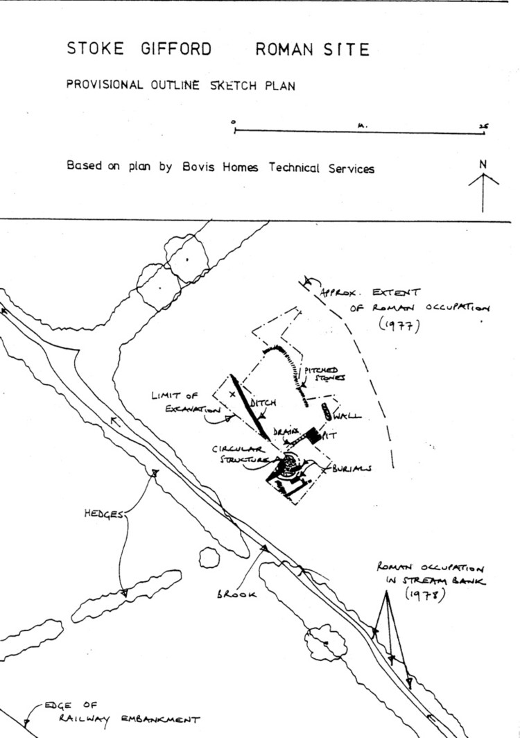
The Roman settlement at Stoke Gifford was discovered in the spring of 1977, and briefly excavated in the following June. Excavations revealed a substantial spread of limestone fragments and some sandstone flags, with finds suggesting that the site had consisted of at least t o buildings, of which one may have been a byre.
During the winter of 1977/78, earthmoving machines destroyed much of the site; the 1978 summer excavations were, therefore, intended to define the remaining (if any), Roman structures establish the chronology of the site, and, if ‑possible, to recover a worthwhile sample of occupation material.
In June, 1978, the annual two‑week training excavation of the Department of Classics and Archaeology (as it is now 1mown) again took place at Stoke Gifford. Two areas, to west and south of the previous excavations, were cleared of contractors' spoil, and a large area, formerly unexcavated, was cleared in the southwest corner of the site. The latter proved, like the rest of the site, Ito have been severely rutted by machinery in 1977; almost all the features planned in the two years' training campaigns turned out to be wheel‑ruts. Moreover, what had formerly been tentatively interpreted as a Roman wall turned out to be a modern field‑drain, and it was clear that ploughing and earthmoving between them had reduced the Roman structural remains to floor level or below. Fortunately, the two areas below the spoil dumps proved more rewarding.
The northwestern area appeared to represent the edge of the settlement; an irregular scatter of limestone petered out towards the modern field boundary. Likewise, in the southwest part of the site, enough remained undamaged to show that the Roman stone scatter became thinner. Here, as also in the southern part of the excavations, the Roman layers were overlaid by a homogeneous layer of brown clay silt, apparently waterlaid; although few finds cane from this layer, it overlay the destruction layer of the Roman site (which indeed, appeared to have been damaged by ploughing before the clay layer was laid down), and may, therefore, represent flooding in modern times. Local people recall bathing in a pool which used to form at this spot.
Work on the available areas of the site was not complete at the end of June, so in July and August excavations continued with the help of volunteers, at first on Sundays, and then continuously from 20th ‑ 28th August. I am grateful to several BAEG members (especially June Williams, and John Hunt) for their help both on site and in recruiting others, to Vic Hallett and Margaret Gray for taking charge when I could not be present , and to Jennifer Gill for her invaluable help with plans and sections. The main area excavated was under the southern spoil tip, and here the Roman remains (although ‑ploughed) were undamaged by modern machinery.
As elsewhere on the site, a flood deposit overlay the debris of the Roman structures. It was not possible to strip the entire area down to natural, but it appears that (in the area of our excavations) the surviving structures were the first on the site, though charcoal flecks and a ?posthole suggest, there may have been some kind of earlier occupation. Coins, from the occupation layers indicate that the site was in use c AD 270‑350: the latest is an AE3 (small bronze coin) of Constans, Victoria Augg (AD 41-6). Study of the pottery may permit an extension of these date limits.
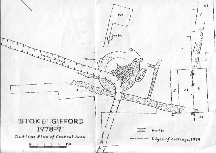
Within the period of occupation, several structural phases can be provisionally distinguished. First, well‑constructed circular structure was built. No trace of a doorway survives, though part of the structure lies beneath the remaining spoil dump. The floor was carefully made of small, tightly‑packed slanting limestone fragments; the structure was 3.9. m in internal‑ diameter, its wall 0.9 m thick at the level preserved (probably a foundation, with offset). No trace survived of any internal arrangements and the original function of this circular structure remains at present unknown.
To the east of this building, a relatively irregular limestone floor, similar to the stony spread observed throughout the site, may have been laid down at, the same time; also possibly contemporary was a substantial line of pitched slabs, running NW‑SE, and probably abutting the circular structure. No trace of any superstructure on top of these slabs survived, but they presumably served as the footing for some form of wall. Occupation material mingled with a considerable quantity of roughly laid lime stone fragments, began to build up to N and S of this footing, before a slightly built partition (with traces of a cross‑partition) was constructed at right angles, running NE‑SW; the circular structure was apparently soon demolished, as occupation spread over the wall, and hearths were made, partly on the floor, partly overlying the wall.
At this stage there were many hearths and ovens in operation over the whole area of the site. Only scanty remains survive of most, but it is hoped to discover their function by analysing samples of ash, burnt clay and stone, crucibles, and slag. Iron slag and iron ore were found commonly on the site, as was coal; no feature to suggest iron smelling, however, was found. The occupation also, produced quantities of bronze scrap and droplets from bronze casting, as well as several whetstones. The sites function was not entirely industrial, however, since animal bones, domestic pottery, and other items were widely found. Iron nails (as well as hobnails) were frequent, but‑at this stage it is impossible to say whether they represent a roof over the working area, or were actually being forged on site.
To the NEE, of the circular structure, a stone‑built drain, laid in natural, led to a square, shallow, pit, 2.0 m square, shallow pit was filled with a dark rubbish‑deposit containing pottery and bone, with no evidence for any function; the SW end of the drain petered out inconclusively, probably owing to ploughing. Further NE, a straight length of wall‑foundation, 0.4 m wide and at least 2.2 m long was planned in 1977, but destroyed before its continuation and its relation to the‑rest of the site could be found.
Probably at this stage in the history of the site, a substantial ditch, aver 0.8 m wide and 0.4 m deep, was cut through the Roman layers. It ran more or less in a straight line NW‑SE across the SW corner of the site, cut the circular building, turned a right angle, and ran out of the excavation towards the SW. Hardly any silting took place before it was filled with large stones, laid relatively carefully at the foot, more jumbled higher up, together with bones and other occupation material, including several 4th‑century coins. In view of the shallow stratification on the site, it is possible that this ditch is a post‑Roman feature, but it appears to underlie the uppermost rubble deposit.
Finally, again apparently before the final collapse of walls, etc, two inhumations were cut into the Roman structures. Both faced east without grave goods; one was in a fairly well‑built cist grave, with floor slabs laid on natural, and side slabs meeting at a peak above the body.
The other, presumably later, was a shallow grave, hardly dug down into the demolished circular building (which it cut into); the skeleton was barely covered by a layer of stones. Although the date of these burials cannot be exactly fixed, they appear to be late Roman, and to predate the final abandonment of the site.
When was the site abandoned? The coin series hardly supports a date much after the mid fourth century. What was the reason? The waterlaid deposit, at least in the areas so far observed overlies the uppermost Roman rubble layer, suggesting that the site was already deserted before flooding took place. However, these conclusions are only preliminary; more work on the finds and the excavation records may cause some revision.
The future of the site is uncertain at the time of writing. Earth moving and services‑construction for the next phase of housing axe due to begin in January, although the exact details of the developers' plans are still under discussion with Northavon planners, and part of the site may remain unbuilt on. I should like to acknowledge the cc‑operation of Bovis Homes (South Ltd, the landowners and developers, and thank BARG for a grant towards the August 1978 excavation; the main costs have been met by the University of Bristol, and everyone involved in the excavation gave their labour free.
*both male, according Ito Dr Juliet Rogers,
 |
|
|
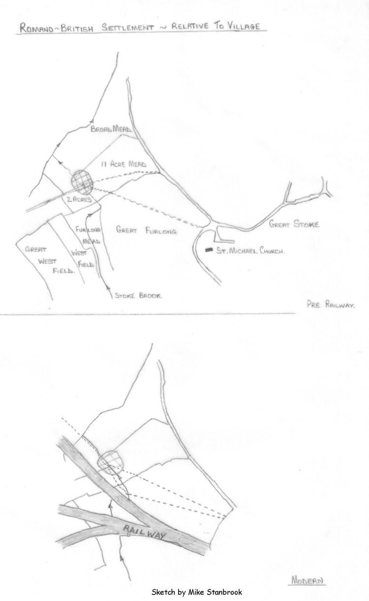
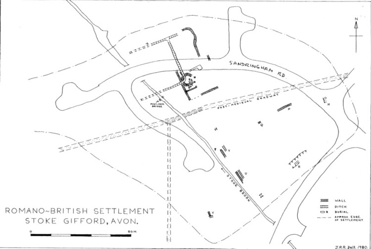
Plan showing additional discoveries made by BARG in 1979-1980 |
 |