
Splatts Abbey
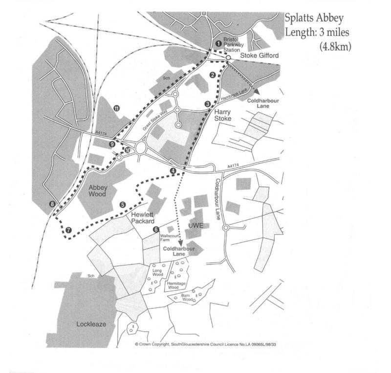
Parkway Station
A shunting yard was originally built on the Badminton Line here in the
early 1900s. In 1970 the shunting yard was taken out and Parkway Station
installed. Takes its name from being designed as a Park and Ride station.
Opened in May 1972.
Sun Life Lake
 A
new pathway winds around the artificial lake. The water tapped for the lake
is also the source of the little stream which winds its way behind New Road
to Stoke Brook. The path follows the route of the old church path to Harry
Stoke Road. The public footpath is diverted via Church Road and Westfield
Lane.
A
new pathway winds around the artificial lake. The water tapped for the lake
is also the source of the little stream which winds its way behind New Road
to Stoke Brook. The path follows the route of the old church path to Harry
Stoke Road. The public footpath is diverted via Church Road and Westfield
Lane.
'The Paddocks'
Walk along Harry Stoke Road 50 metres to the post box in the wall. Over
the wall is the old farm pool, with a resident moorhen. The big farm
building was one of several in the Stoke Gifford Parish. Harry Stoke arm was
renamed The Paddocks early this century.
Harry Stoke Colliery
Harry Stoke colliery was a post-nationalisation venture which was
intended to open up the north Bristol area of the coalfield. The colliery
was a pair of drifts which passed through the beds at a gradient of 1 in 3.
It was also intended to sink shafts once the drifts had reached the deeper
measures, and thus the Harry Stoke Mine was to have been the beginning of a
major scheme in the area. The driving of No. 1 drift commenced in the autumn
of 1952. Unfortunately the bad roof conditions in the seam lowered
productivity to a level where the colliery became uneconomic and the
National Coal Board closed the mine in June 1963.
Splatts Abbey Wood
A small wood with several names. As far back as 1725, it is recorded as
'Platts Wood'. Up to date records all slightly change the name to Splatts
Abbey Wood and more recent development influence gives it the title of Abbey
Wood (1996).
Walls Court Farm
The Manor of Walls is recorded as being the third manor comprising the
Parish of Stoke Gifford. An area of considerable woodland known as 'le
Walls'. The farm was mostly so poor that it earned the name of 'Starve-all
Farm'. In the 19th century Thomas Proctor transformed Wallscourt Farm into a
model estate. He left in 1861; and almost 100 years later, Hewlett Packard -
an American computer company - bought the land (1960). They faced a dilemma
of whether to demolish or retain the classic structure. The company chose to
retain and restore the old building as a training centre.
Stanley Farm
About 700 yards (640m) away, Stanley Farm was built by Thomas Proctor in
1855. It was only 84 acres. Now it is part of the Ministry of Defence
Procurement Centre. Most of the farm house had deteriorated, but, like
Hewlett Packard, the MoD restored the budding.
Stonebridge
This small footbridge over the railway line to Temple Meads is sometimes
known as the Blue Bridge because of its concrete structure. It carries
Footpath LSC21 from Filton Avenue.
Wallshut Wood
This very old wood was ripped out by the development of the Homeworld
car park in the 1960's.
The Brook
This small stream meanders round the site of the MoD and past Abbey Wood
Railway Station and Homeworld, eventually joining Stoke Brook. It flows
under the Ring Road (A4174) emerging briefly before going under the playing
fields of Filton High School. It reappears between Stoke Gifford and Little
Stoke - see item No. 9 in 'Nowhere and Back'.
Avonsmere Park
Not actually in the parish of Stoke Gifford (Filton). The boundary runs
through the builders Merchants. The Mile straight returns us to Parkway
Station.
© Stoke Gifford Parish Council